By David A. Welker – https://www.davidawelker-civilwarhistorian.com/
A recently discovered 1864 map suggests the Cornfield’s human cost was even greater than previously understood, among other new insights it reveals about the men who fought in and around David Miller’s deadly Cornfield…
This spring, Adams County Historical Society researchers Timothy Smith and Andrew Dalton discovered a map in the New York Public Library that depicts the burial location of 5,844 soldiers killed on America’s bloodiest single day, September 17, 1862’s Battle of Antietam. Offering new and unique glimpses into this horrific moment in American history, it also reveals new insight into the deadliest portion of that battle, the struggle for the Cornfield and its related actions. [i]

Created two years after the battle by Simon Green Elliott (1828-1897), who before the war worked as a railroad engineer in California, Elliot also mapped Gettysburg battlefield’s burials, which has long been famous and is housed today in the Library of Congress. [ii]


Walking the ground around Sharpsburg, which remained a massive cemetery in 1864, Elliot was able to document in great detail the exact number and location of Antietam’s dead. He recorded the hand-hewn grave markers and headstones bearing names of a few of the fallen, created in Antietam’s immediate aftermath by friends and brothers. Elliot captured temporary markers left by Union burial details to record for later reburial teams the mass resting place of several regiments, both Union and Confederate. He also recorded the location of artillery batteries, although these reflect not Elliott’s personal observation but rather locals’ or other witnesses’ accounts because by 1864 these guns had long-ago moved on to other battlefields. Because by 1866 and the opening of the Antietam National Cemetery and other such grounds most of the burials Elliott depicted had been moved elsewhere, his record offers us today a glimpse of a moment in time that is no more. [iii]
National Park Service historians have published the first detailed analysis of Elliott’s map on Antietam National Battlefield’s webpage (follow this link to their page: https://www.nps.gov/anti/learn/historyculture/elliott-antietam-burial-map.htm). They revealed that Elliott’s map lists 5,844 total graves. 2,634 of these are Union fallen, 40 of which are named. 3,210 Confederate graves are recorded, with 10 of these being named. 269 horse burials are captured, in 40 locations. The NPS includes stories of several of the map’s named soldiers, noting that “This remarkable resource confirms much of what we know about the locations of burial trenches from Alexander Gardner’s battlefield photos and period sketches” and that Elliott’s map “raises many new questions for Antietam scholars.” [iv]
This is certainly true of Elliott’s depiction of the human cost of the Cornfield fight and taking a focused, detailed look at this portion of Elliott’s map and assessing these findings offers previously hidden insights about the fighting on D.R. Miller’s farm.
A quick glance at the map instantly shows the greatest concentration of burials are centered in and around David Miller’s Cornfield, suggesting that the battle’s greatest number of immediate deaths occurred there. Although Union and Confederate casualty numbers from after the battle (regimental returns) have long suggested this was the case, this easy visual “graph” drives home that point in an unforgettable way. [v]

Examining the number of burials Elliott depicted north of the Dunker Church also provides the first detailed count of soldiers killed in the Cornfield fight and its related actions in the East and West Woods – the fighting on the Confederate left/Union right. My count has Elliott depicting 3,759 burials here, of which 2,219 are Confederate and 1,540 are Union fallen.
This number also suggests that Antietam historians have greatly undercounted the number of men killed in the Cornfield and its related actions. For example, Antietam historian and 13th New Jersey Colonel Ezra A. Carman lists roughly 986 total Union troops killed here (a number created by combining his killed number for the I, XII, and one third of the II Corps figures), while Elliott shows 1,540 Federal burials – a 554-man undercount. Carman notes 1,133 Confederate dead on Lee’s left, while Elliott’s map depicts 2,219 killed – a 1,086 undercount. In fact, the 3,759 burials Elliott depicts north of the Dunker Church are only 105 more than Carman lists for the entire battle. Although Carman and other historians (including this blog’s author) frequently drew upon all the sources then available, Elliott’s map offers valuable new insight to Antietam’s human cost. [vii]
The lives of more horses, too, were claimed in the fighting in and around Miller’s Cornfield than elsewhere at Antietam. A count of those horses buried north of the Dunker Church area shows 168, the bulk of the 269 the NPS counted on the entire map. [viii]
Some of the individual soldiers named on Elliott’s map who fought in and around the Cornfield have their own stories to tell, too. These include:
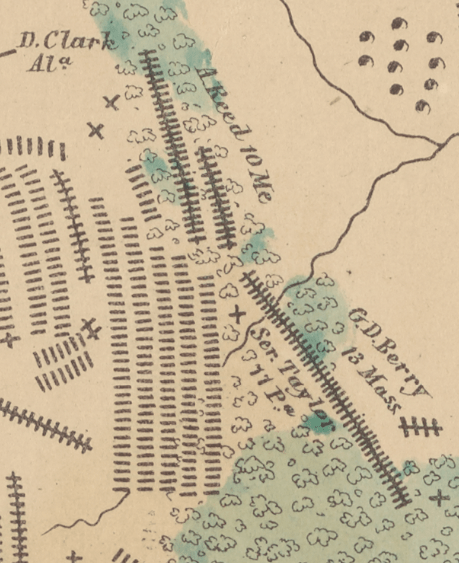
Sergeant Isaac S. Taylor, 11th Pennsylvania: Recruited in the tiny, central Pennsylvania hamlet of Jersey Shore, Isaac was mustered into the 11th Pennsylvania’s Company D as a sergeant. Surviving combat at several previous actions—Cedar Mountain, Second Bull Run, Chantilly, and South Mountain—he and the 11th marched to Antietam as part of Brigadier General George L. Hartsuff’s Brigade within Brigadier General James Ricketts’ Division, all part of Major General Hooker’s I Corps that was to open the Union attack by advancing into Miller’s Cornfield at dawn. Although Hartsuff’s wounding and the consequent confusion that event created spared Taylor and the 11th from the Union advance’s initial moments of terror, it left them to endure Confederate shelling until order was restored and they advanced. Then, pushing south into the Cornfield, Sergeant Taylor and his comrades replaced Duryee’s shattered brigade to face down Brigadier General Harry Hays attacking Confederate brigade. Halting Hays cost the regiment greatly, and it might have been here, amidst the still-tall stalks of corn and barely hour old fight that Isaac Taylor fell. His initial resting place on the western edge of the East Woods was likely not far from where the 11th fought. Isaac’s earthly remains were reinterred at Antietam National Cemetery by 1866. [ix]

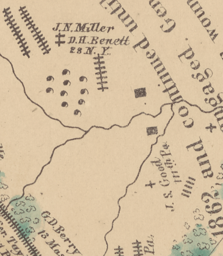
Corporal John S. Good, 111th Pennsylvania: Joining the 111th Pennsylvania’s Company B on November 2, 1861 as a corporal, like many others in the regiment Good was from near Erie in northwest Pennsylvania. The regiment had been given easy duty guarding Baltimore, Harpers Ferry, and other locations, even missing fighting at Second Bull Run by being assigned to guard the army’s wagon train. Combat the the regiment at Cedar Mountain, too, had been light and if the men felt lucky with these assignments, their luck had run its course by September 17th. Assigned to Lieutenant Hector Tyndale’s Brigade in Brigadier General George Greene’s Division of the XII Corps, Good and his comrades joined in forming the “swinging door” that would finally sweep the East Woods clear of Confederate defenders and secure the Cornfield for the Union. For Corporal John Good, however, that attack may not have lasted very long because his first burial place suggests he may have fallen early in the drive into the East Woods. His remains today are unlocated. [x]
George D. Berry, 13th Massachusetts: George was 22-year-old currier—a leatherworker—from Tamworth, New Hampshire when he enlisted on July 16, 1861 as a private in the 13th Massachusetts’ Company G. He and the regiment had visited Sharpsburg before, in August 1861 when guarding Potomac River crossings, and the regiment had spent much of its war service to date in Maryland. Their first major combat came in October 16, 1861’s Battle of Bolivar Heights, near Harpers Ferry, and despite being in reserve at Cedar Mountain had experienced considerable fighting in Virginia, taking active part in battles at Thoroughfare Gap, Second Manassas, Chantilly, and Maryland’s South Mountain. Advancing south into the Cornfield to relieve Duryee’s Brigade, George and the 13th Massachusetts’ left flank formed on the East Woods as their fighting opened, which left them in the open of the Cornfield to face Hays’ advancing Confederates. The 12th Massachusetts suffered the most casulties of any Union regiment at Antietam, taking 224 casulties of the 334 it took into the fight, 74 of whom were killed – including George Berry. Those comrades who buried George and marked his resting place along with three others from the regiment, probably did not have to move him far from where he fell. George’s remains were taken home to Massachusetts and lie today in the Lindenwood Cemetery in Stoneham. [xi]

Corporal David Bennett, 28th New York: Only 19 years old, David enlisted at Medina, New York on April 30, 1861 to serve two years in the 28th New York’s Company D. Roughly one year later David was promoted to corporal, in time for the regiment’s first major combat at the May 24-25, 1862 First Battle of Winchester. David and the 28th suffered heavily at Cedar Mountain, losing 213 of its 339 men, casulties so great that in fighting at Second Manassas the regiment was reduced to a four company battalion commanded by Captain William H. H. Mapes, who led them into Antietam’s Cornfield. Assigned to Brigadier General Samuel Crawford’s Brigade, in Brigadier General Alpheus Williams’ Division of the XII Corps, the 28th was one of the brigade’s three veteran regiments—as opposed to three massive green Pennsylvania units—and charged with holding the eastern end of the Cornfield while Major General Mansfield oversaw clearing Rebels from the East Woods. Succeeding in that task cost the 28th New York only one officer, one man missing, and eight men wounded, one of those mortally. That mortally wounded man was Corporal David Bennett and perhaps it was this unique status that led friends to mark David’s grave east of the East Woods. [xii]
Asa Reed, 10th Maine: Born in Danville, Maine on November 28, 1840, Asa was a 20-year-old laborer when he enlisted in the 10th Maine’s Company K on October 16, 1861. Assigned to the Railroad Brigade, the 10th spent its early service guarding railroad bridges until experiencing serious combat at Cedar Mountain. Although it avoided fighting at Second Manassas by being assigned to guard the army’s wagon train, along with the 28th New York the 10th Maine was another of General Crawford’s veteran regiments. Unlike its brigade counterpart, however, Asa and the 10th Maine were led by XII Corps commander Major General Joseph K. F. Mansfield to the eastern side of the East Woods as part of the force clearing Southerners from the woods. Exposed to intense concealed enemy fire from the woods, Mansfield fell mortally wounded and was carried away to a nearby field hospital. Private Asa Reed soon joined the general in death, although his remains traveled only yards from where he fell near the East Woods. Asa was reinterred in Antietam National Cemetery by 1866. [xiii]
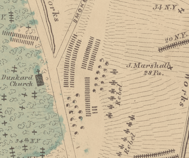
John Marshall, 28th Pennsylvania: John Marshall is unique among the named fallen on the Elliott map. Born in Ireland in 1812, John was 50 years old—considerably more seasoned than his comrades—when he enlisted on July 27, 1861 as a private in the 28th Pennsylvania’s Company L. A stonemason in Allegheny City—which became part of Pittsburgh in 1907—John left behind much upon enlisting for although his first wife had died of consumption in 1855, their son William remained at home, as did John’s second wife Mary—18 years his junior—and their sons two year old Samuel and infant John, Jr. John Marshall and the 28th also marched into their first major fight that morning at Antietam, despite having served for most of the war to September 17, 1862. Assigned to Lieutenant Colonel Hector Tyndale’s Brigade of Brigadier General George S. Greene’s Division of the XII Corps, they waited while Hooker’s I Corps men battered themselves in taking and retaking the Cornfield. Sometime around 8:30 that morning, however, the 28th and Tyndale’s Brigade was sent into action as part of the “swinging door” advance. Driving through the East Woods and finally securing the Cornfield, John and his regiment relentlessly advanced until reaching the Hagerstown Pike’s eastern edge. Short on ammunition, the 28th and Greene’s Division remained aligned on a slight rise—roughly where today’s NPS visitors center stands—for over an hour before pushing across the road to secure the Dunker Church, where they remained until being driven back sometime before 1:00 p.m. John Marshall, however, probably never witnessed the regiment’s stand around the Dunker Church given the location of his burial. John’s final unique feature is that his battlefield grave was captured by photographer Alexander Gardner, shortly after the battle. Photographic historian William Fassanito in 1978 confirmed the location by identifying the still-existing rock formation and enlarging the image to read John’s name inscribed on his wooden marker. John’s body was moved to the Antietam National Cemetery by 1866 but the loneliness and sadness of his battlefield resting place haunts viewers even today. [xiv]


Simon Elliott’s priceless map has opened new insight to the Battle of Antietam, particularly to the human toll demanded by this bloodiest day in American history. Just as Elliott’s map shows by a simple glance, nowhere was the price required of those who fought at Antietam higher than in and around David Miller’s deadly Cornfield.
[i] Elliott, Simon G. “Map of the battlefield of Antietam,” 1864, New York Public Library, Digital Collections, Image ID 57493764 (https://digitalcollections.nypl.org/items/185f8270-0834-0136-3daa-6d29ad33124f) (hereafter “Elliott Map, NYPL”); https://www.nps.gov/anti/learn/historyculture/elliott-antietam-burial-map.htm.
[ii] https://www.nps.gov/anti/learn/historyculture/elliott-antietam-burial-map.htm; Elliot Map, NYPL.
[iii] Elliott Map, NYPL.
[iv] https://www.nps.gov/anti/learn/historyculture/elliott-antietam-burial-map.htm; Elliot Map, NYPL.
[v] Elliott Map, NYPL.
[vi] Carman, Ezra and Thomas G. Clemens The Maryland Campaign of September 1862, Vol. II: Antietam (El Dorado Hills, CA: Savas Beatty, 2012), pp. 601-611.
[vii] Carman, The Maryland Campaign, Vol. II, pp. 601-611; Elliott Map, NYPL.
[viii] Elliott Map, NYPL; https://www.nps.gov/anti/learn/historyculture/elliott-antietam-burial-map.htm.
[ix] http://antietam.aotw.org/officers.php?officer_id=10553; Welker, David A. The Cornfield: Antietam’s Bloody Turning Point (Philadelphia: Casemate Publications, 2020), pp. 82, 85-86.
[x] http://www.pa-roots.com/pacw/infantry/111th/111thcob.html; Welker, The Cornfield, pp. 162-163, 210, 218.
[xi] 13th Massachusetts Infantry Roster, http://www.angelfire.com/ca5/4xmas/b.html;.https://civilwarintheeast.com/us-regiments-batteries/massachusetts/13th-massachusetts/; https://www.findagrave.com/memorial/43218843/george-o-berry; Welker, The Cornfield, pp. 71, 81-82.
[xii] Annual Report of the Adjutant General of the State of New York For the Year 1893, Volume 21, p. 294; https://civilwarintheeast.com/us-regiments-batteries/new-york-infantry/28th-new-york/; Welker, The Cornfield, pp. 138, 144-150.
[xiii] http://antietam.aotw.org/officers.php?officer_id=3987; https://civilwarintheeast.com/us-regiments-batteries/maine/10th-maine/; https://www.findagrave.com/memorial/52153096/asa-reed.
[xiv] William A. Frassanito Antietam: The Photographic Legacy of America’s Bloodiest Day (New York: Scribers, 1978), pp. 171-173; https://www.findagrave.com/memorial/7065619/john-marshall; https://www.nps.gov/anti/learn/historyculture/elliott-antietam-burial-map.htm; US Library of Congress, Prints and Photographs Division, Alexander Gardner, “Antietam, Maryland. A Lone Grave,” LC-B811- 570 [P&P] LOT 4168; Welker, The Cornfield, pp. 102, 159, 210.

Why have most publications concerning the Battle of Antietam stayed with the original death count from the battle when the Elliot map shows, with a great degree of certainty, there were 5844 Americans killed during that bloody single day in 1862?
LikeLike
It’s a great question! My sense is that largely it’s because the unofficial “official numbers” have been set for so long and used so widely that changing them is a slow, difficult process. Only with greater use over time will it change and even then, very slowly. In the last few years, the overall number of Civil War casualties has grown from Fox’s late 19th Century number of roughly 620,000 to 720,000, to reflect the ambiguity of how he arrived at that figure and to account for the many men simply not counted for various reasons. Antietam’s casualty figures suffer the same issues, but Elliott’s map adds new data and structure to that process.
LikeLike
This article repeats the typo from the National Park Service website and must have used it as a reference. 2644 Union dead and 3210 Confederate dead. Does anyone here and at the NPS know how to add?
LikeLike
I’ve corrected the error, as has the NPS, which as I noted was used as a source.
LikeLike
Important to remember that the supposedly understated figures compiled by Carman contain a number posted as missing in action – an aggregate of more than 1,750- and it’s anybody’s guess as to how many of these had actually been killed or were left dying on the field. In addition, of course, the huge number of more than seventeen thousand wounded included close to two thousand who would die of their wounds in the battle’s aftermath. If we allow for both these categories, the difference between the Carman figures for killed and the numbers in the Elliot map can be – in part – explained.
LikeLike
Spot on! Getting really accurate numbers for casualties is always a major challenge. In large part this is because the army had no formal, required accounting of battle casualties beyond what was necessary to record how many men remained for duty and to prepare for coming ration needs, etc. This (today dated) view is one of the reasons why commanding officers almost never notified family of a man’s death, because their loss was viewed differently than it is today. And that different view explains in part why the army didn’t account for casualties more accurately.
LikeLike
Thee implications of that map are challenging.
They very much endorse the claims made by McClellan in his assessment of the casualties of the battle. They suggest that Lee exposed his army to outrageous punishment and suffered accordingly.
This is uncomfortable for those of us who seek refuge in the more commonly accepted figures provided by Carman .
What were the numbers of Confederate dead who were subsequently exhumed from the battlefield and reinterred elsewhere ?
LikeLike